Mark had a rare experience Saturday: He got to take a time machine ride. But I'm not sure he realized that's what it was. I think to him it was a rough mountain bike ride where he had to push his bike a lot. But it reminded me of mountain biking when I started riding 18 years ago.
Back then there were no websites like UtahMountainBiking.com where you could browse a list of good trails, take your pick and be rewarded with a fine ride. Back then we just had topographic maps and trail ideas from hikers and horse riders. (I'll bet all you veteran riders are already having flashbacks of "epic" rides you've been repressing all these years - I apologize for the emotional distress you are now feeling, but I must continue so MTB history may be appreciated.) Sometimes a ride would start like this: "Billy Bob rode his horse on this trail and he said it would be a great mountain bike ride!" Or we'd pull out the USGS topo maps and look for the dashed "Pack Trail" lines. Then off we'd go with visions of sweet single-track. But of course 2nd and 3rd hand stories and maps more often mislead than inform and we had many an epic "adventure" as we attempted to make a bike go on trails fit only for hooves or feet. Perhaps one relevant example would be useful:
Around 15 years ago my brother and father and I set out for a ride across the front face of Timp. We took the dirt road in and started on the trail at Big Baldy (broke a chain along the way - not a good omen). Sadly, we missed the trail and pushed our bikes up the gully to the saddle on a hot Summer day. At the top of the saddle we then went down the most horrific trail I had ever encountered. It started out OK, but quickly turned into a trench more than a foot and a half deep. And it was so steep we were clear off the back with our stomach on the saddle. It was a game of "don't snag a pedal on the side of the trench" combined with "use all the brake you can without skidding". I remember one or more sections where I had maybe 10% more brake to give and then if it got looser or steeper it was going to be runaway train time ending in some sort of crash. Somehow we made it back to civilization - exhausted from the effort and stress. But it's all just a happy memory now - except for those nights I awake dripping in sweat with my hands clenching the imaginary brakes ;-)
Mark coming to a switchback early in the ride.
Back to today's ride. We started at the Timpooneke trailhead and veered right onto the Great Western Trail. It starts right off with a stiff climb then circles around the upper campground - not too bad so far. Then we headed up the trail leading to Julie Andrews Meadow and it was ugly - lots of loose rock, steep and it just kept going. We rode a few short stretches, but it was mostly push-a-bike. We'd been warned that this section would be bad, but we had to see for ourselves. My advise is to skip it by exiting the trail and taking the road up to the next trail crossing. You can even do a short out-n-back if you really want to see the meadow. Well, we made it to the meadow, but being Fall it wasn't awash in wildflowers as it would be in Spring, just nearly dead tall grass. But at least the trail was better.
Julie Andrews Meadow in the Fall - not as spectacular as Spring.
After the meadow the trail was nice as it passed through thick stands of trees. Then we crossed the road and enjoyed a nice descent into Rock Canyon, then some semi-rugged trail and a good climb back up to the road for the second crossing. From here the trail climbs steeply to the high point in the trail after which it rolls up and down but stays fairly level. Soon we had gone around the north end of Timp and were rewarded with a nice view out over Utah Valley. Then a long descent down a pretty good trail to the third road crossing at the top of Grove Creek canyon. The trail was rough on the descent, but OK as it sidehilled heading south. At one point I missed a turn in the trial that went down, but luckily as I continued along on one of the old CCC terraces it met back up with the trail coming up and we were spared some unnecessary climbing. We made our way over to the top of Battle Creek canyon, and here's where the "fun" began.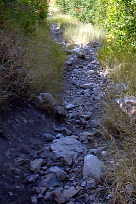
This is Battle Creek - nice, huh?
Battle Creek is steep and more than rugged. The trail started right off with a bang - a steep chute loaded with loose rock from marble on up to basketball sized. We rode some, walked some. By now it had already been a pretty tough ride and I just didn't have the moxy for rock surfing, even with Mark's goading. It was a pretty awful trail, from a mountain biking persepective, but we finally made it to the turnoff for the Curly Springs trail. Sadly, this meant going up, steeply. We pushed much of the first steep slope, but then came a section we could ride then one more push to the top. I'm not sure what Mark made of this bike unfriendly section, but from his neutral-ish replies I had hope he wasn't plotting my "accidental" death (but perhaps that's because I was his only hope of getting out of here).
The Altar - nearing the end of the ride.
After we topped out of Battle Creek, we had a pretty nice ride on a good trail down to Curly Springs. Just past the springs we turned left and took an OK trail into Dry Canyon. From here we had a choice: descend Dry Canyon down to my house, or take a trail that climbs out of the south side of Dry Canyon. Mark was game to try the climb-out trail. I've come down it 3-4 times and knew it was steep in spots, thankfully it wasn't too bad to go up, even though we had a walk a few times. Once at the top we had a nice ride back to the Altar at a 4-way trail intersection then down to the dirt road and finally into Orem near the cemetary.
From the GPS track it was 20 miles with 2700' climbing and 5300' descending with a start to end time of 4 hours 45 minutes. Here's what it looked like in Google Earth:

Mark has a short ride report and more photos on his blog, UTRider.

To Update Or Not To Update
4 weeks ago
2 comments:
The hike-a-bike sections don't sound fun, but I do like most of that perimeter trail. Sorry I missed out. Glad you started a blog, your mountain gps pics are sweet!
Kris,
Adam told me you are working on the Timp Trail naming project. Where are things at on that. Do you have a seperate blog. Let's do some off season planning for early 2009, perhaps the team can help.
Post a Comment