As I glanced out my window at lunch my eye caught the sight of smoke in the distance. I went outside to see this (taken at 12:40 PM):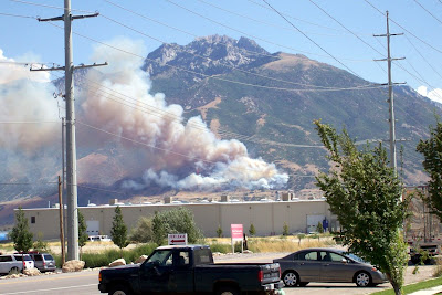
It's in the foothills of Lone Peak north of Corner Canyon in Draper. I work on 14600 South and the fire is due east. Looks like it's above the fire road and Bonneville Shoreline Trail. It's a bad day for a fire - temperatures in the upper 90s and a constant south wind. If they don't get on this fire quick, it could burn big.
Reminds me of the fire in the foothills of Mount Timpanogos a few years back. It was eerie to look from my house and see the flames - especially at night.
One of the local news outlets has some info.
Update 1:20 PM - Here's what it looks like 40 minutes after the above photo was taken:
The fire is moving up the mountain and the wind is pushing it north. It's creating a big plume of smoke. I saw a tanker plane fly over, but not dump anything - my guess is they're doing reconnaissance.
Update 2:15 PM - The fire keeps growing. It has burned north of Cherry Canyon now and farther up the mountain. Hard to tell how far north the fire is because the smoke is obscuring that area. It's burning south, but very slowly due to the wind.
I saw a small plane fly into the smoke and back out. Probably fire officials having a look.
All of the local news media I checked are now following this fire.
Update 3:00 PM - The fire is still growing, but it's hard to tell where it's burning because of all the smoke. It seems it's still burning fierce because the column of smoke is much bigger and has created a mushroom cloud. I'd guess it has burned over to Bear Canyon by now. But it looks like it has not burned down into the houses - at least I hope so.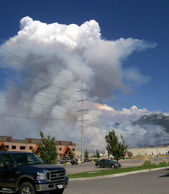
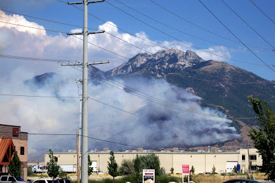
Update 4:20 PM - The fire is looking considerably less fierce. No more big column of smoke, in fact the smoke is much reduced overall. In the photo you can see two planes (near the power pole) - one is a tanker for sure, but the other I'm not sure. Along with the fire suppression work going on, my guess is the fire has moved into rockier terrain with less fuel and this has calmed it down.
It doesn't appear that the fire has moved south, so good news for Corner Canyon and Suncrest residents.
The news reported that some residents were evacuated east of the Hidden Valley Country Club (11700 to 12300 South).
The blackened mountain side is ugly, but if the fire can be stopped now I'd say we got off pretty good. Here's hoping.
Last update today 5:05 PM - Looks like the fire is still dying down. Here's hoping it's on the way out.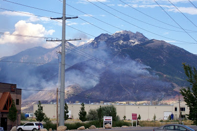
Update next day 10:00 AM - Not a good picture as it's hazy today. The wind shift over night and was generally coming out of the north, but it didn't seem to push the fire south much, thankfully. The fire line on the north appears to be between Cherry and Bear Canyons, that also seems like good news that it didn't go more north toward Little Cottonwood Canyon. The weather should be cooler today and much less wind. The fire has died down a lot. My guess is they should have it out in a few days.
No more updates unless the fire flares up.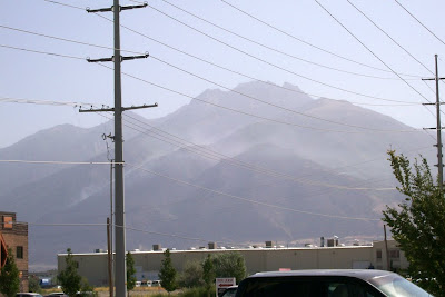
Update next day 12:15 PM - No photo this time. Less fire than at 10 AM. The news is saying that only the lower edge of the fire is contained, but I couldn't see any smoke coming from the south edge where the fire burned. I can see a few spots of smoke coming from the north and top edges. I'm sure there are still some hot spots, but I'd say the worst is over.
Backups Make Everything Better
4 days ago
12 comments:
that's not good.
hope it's contained pronto
I hope it takes out some of the obscene mc'mansions, provided they are empty of course.
That'll fix 'em. (rolling eyes) Of course, insurance will pay for them and they'll rebuild -- farther up the mountain and with a bigger house.
Be careful what you wish for.
...or insurance will pay off their soon to be foreclosed mortgage and they will move to more reasonable digs.
Seriously there is a 23,000 square foot house right next to the trail down there. Who needs that much space/Resource usage/ etc????
oh yeah, KK that link to cycling related tattoos you posted over at Fatty's should really be enough of a deterrent that Kenny will reconsider and not get one, I mean really, most of those tats were way bad.
No one needs a 23,000 foot home, that's for sure.
But wishing that person has the home burnt to the ground is pretty much the same as someone hoping the cyclist on the $5,000 ride has his bike run over by a semi truck -- after all, no one 'needs' a $5,000 bike.
touche'
stupidbike - Maybe this capitalist country isn't for you. ;-)
But seriously, I agree, shows of excess are distasteful. But perhaps I'm judging hastily, maybe they're running an orphanage in that massive house.
Yes, a few of those tattoos were cool, but would you really want any of those on your skin for the rest of your life? And if Kenny just wants a small tat he can easily hide, what's the point? I should offer to draw on him with a permanent marker to see if that will sooth his tattoo itch.
It looks like the fire has stayed out of the draper trails for the most part. Can you confirm?
I was planning a ride up Hog Hollow and down Jacob's Labber, Ghost Falls and up Clarks. I think that will be postponed.
Maybe I'll night ride Lambert so I know where the fire line is.
The fire is well north of the Corner Canyon trails. The BST from Corner Canyon past Bear Canyon and on to Willow Park is probably closed, or should not be used due to fire danger.
But I would recommend staying away from the Corner Canyon trails, and any others in the area until the fire is out, or at least contained. The weather is supposed to shift tonight - hopefully for the better, but it could result in the fire moving south. Better safe than sorry - there are other places to ride. That's my advice.
Do any of you guys work at work?
Maybe if you "worked" instead of blogged you could afford to need that 23,000 sqf house. Just kidding, you guys are funny.
There was a fire up on Squaw Peak last summer that I was really worried about destroying the trails. After a few weeks, the regrowth started, and turned the hillside into a charcoal and green landscape. If you have a Facebook account, you can see a picture here.
Post a Comment